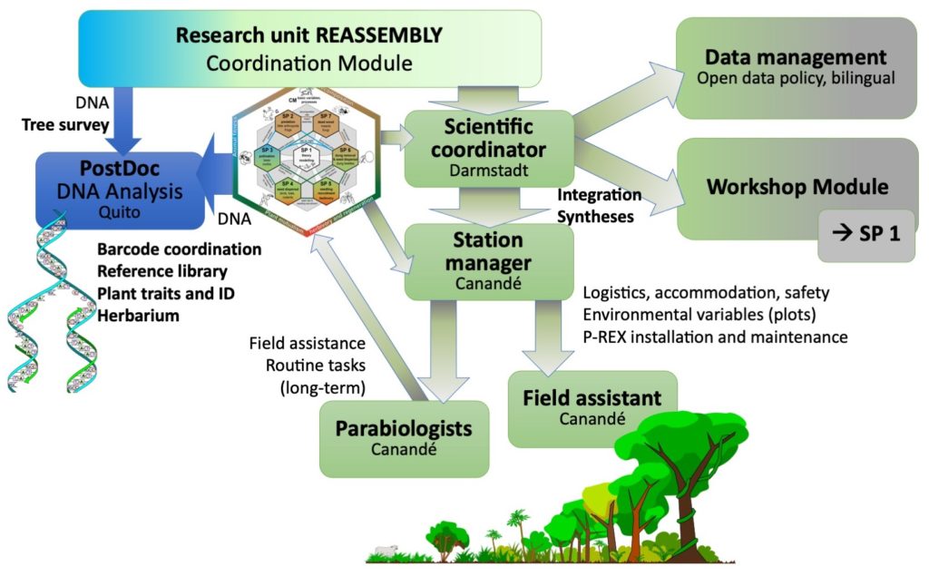
The scientific coordination among subprojects and with partner organisations, logistical organization, data management and storage and support on site in the study area are the main responsibilities of the Coordination Module (CM) led by Nico Blüthgen and Martin Schaefer. The scientific coordinator (Edith Villa-Galaviz) is the main hub in this network of tasks, strongly linked to the station managers who coordinate research station and field teams (plot manager, parabiologists). CM will obtain environmental baseline data, assist with forest inventories and quantify processes in the experiment (see list below). CM will encourage, support and provide syntheses across subprojects in combination with SP1. DNA analysis (barcodes) and botanical work is organised by Sebastian Escobar in María-José Endara’s lab at the Universidad de las Américas, and will also help with permits for collection and transport of samples. In David Donoso’s lab at Escuela Politécnica Nacional, a Disc3D insect scanner system will be implemented to make specimen from the project and parts of collection of Ecuadorian museums available to the public (see New ant species described in 3D and various other species here).
List of baseline field data provided by the coordination module for all subprojects
Forest structure, abiotic and biotic variables in all plots
Tree size (dbh, height estimate), tree species composition, tree growth (dbh)
Soil quality (at two layers, CN measures)
Vertical vegetation structure
Canopy closure, light availability
Temperature and humidity for each plot
Precipitation for each region (near each of the huts)
Litter: amount, density and composition in perturbation treatment (weight and volume removed, separated by foliage and twigs/branches of different size categories)
Mammal species lists (camera trap data)
Compilations of plant species where available, including obvious herbs, shrubs, lianas, epiphytes; bird lists and other taxa where available
Landscape composition
Habitat area and shape for each category (plantation, pasture, secondary forest, primary forest)
Distance to nearest forest margin
Landscape composition at different spatial scales
Exploration and inclusion of satellite and remote sensing data from collaborations
Ecosystem processes
Litter fall weight and volume in each plot for litter traps, separated by foliage and twigs/branches
Carbon stocks and fluxes
Processes in experiment (in addition to those monitored by subprojects), e.g. standardized decomposition rate of litter bags and tea bags, dummy caterpillar predation rates, standard seed removal, nectar consumption rate, herbivory at phytometer plants